Location

The town of Dunwich was located in the county of Suffolk, in the East of the United Kingdom. The town is now an attractive village situated on the Suffolk coast just to the north of Minsmere RSPB reserve and south of the river Blyth estuary at British National Grid TM 47678 70558 Degrees 52.27731°N, 1.62937°E
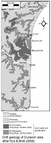
Dunwich is located on Plio-Pliestocene sands and gravels of the Norwich Crag and Westleton beds. These contain eratic clasts including granite and gritstone from the north of Britain.
")
Dunwich located on the Suffolk Coast of England, in the southeast region of the North sea. Lower figure shows the existing parish boundary in yellow. (Maps derived from Google Earth).
Marine transgressions and fluvial processes have created a shallow valley and former estuary to the north of Dunwich. This has subsequently been filled in by estuarine sediments with the closing of the spit and barrier beach that runs south from Walberswick.
The Dunwich river now runs north through the Dingle and Walberswich marshes to join the River Blyth at Walberswick harbour. Land use in the parish is dominated by heath, marsh and coniferous and mixed woodland with some improved pasture.

St James St. looking east past the Museum and the Ship Inn towards the former gate into the town which lieas in the trees at the end of the road.
Links
