, David Sear (University of Southampton, Project Leader), Adam Cross (EMU Ltd Senior Hydrographic Surveyor), Ian Chambers (Skipper), Ed Hendon (EMU Ltd Project Manager).")
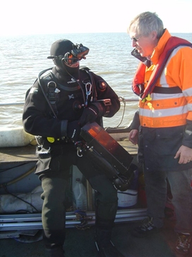
L - R: Stuart Bacon (Suffolk Underwater Studies, Project Advisor), David Sear (University of Southampton, Project Leader), Adam Cross (EMU Ltd Senior Hydrographic Surveyor), Ian Chambers (Skipper), Ed Hendon (EMU Ltd Project Manager).
No project runs on any one individual, and so it is with the Dunwich project. In addition to our funders, we would like to acknowledge the support of the people of Dunwich and in particular John Prior, Kath Chant and the Dunwich Museum Trust. We have also received support and encouragement from English Heritage Maritime Archaeology Team and in particular Peter Murphy and Ian Oxley. Closer to home, the Cartography and GIS were developed by Andy Murdock and Gemma Donaghue from the GeoData Institute, and the Webste was developed by Jason Sadler also from GeoData Institute. The Geophysical survey was supported by Richard Cooke from EMU Ltd, and by Tim Lebas from the National Oceanographic Centre.
Diver support was provided by Learn Scuba led by Andy Rose, Duncan Coles & David Thomson. Dive support was also provided by Historic Wreck Recovery, led by George Spence, assisted by Kevin and Andy Spence.
Media divers who provided great assistance in the project included all at Arcadia Entertainment Productions, The BBC One Shows Dan Snow and team, and the BBC Oceans Frank Pope and team.

L - R: Divers, George Spence, Duncan Coles, Stuart Bacon, Andy Spence and Andy Rose.
Dr Alex Kent of the Cartographic Unit at Southampton University School of Geography.
A big thanks too to all those at the Dunwich Museum who have provided a place to display the work and who have been so supportive of the project.
A final thanks goes to Mrs Jenny Bridson for putting up late arrivals on her doorstep and for happily being dragged along to seriously Dunwich meetings!
Cartographic design for the museum posters and some of the images in this website was provided by Pam Baldaro, Bob Smith and Dr Alex Kent, formerly of the Cartographic Unit at Southampton University School of Geography.
Mike Sawkins (R), instructing Andy Rose (L) in the delights of DIDSON
The Most recent Dunwich work have benefited hugely from the involvement of Wessex Archaeology and their Geophysics team. Paul Baggaley has been tremendous. In NOC Tim LeBas has provided great help and no end of enthusiasm!
A special mention must go to Mike Sawkins from McArtney-AS, who has worn a track up to Dunwich, bringing us the delights of the DIDSON-DH system. He has been completely unflappable throughout.
On the land, a big thanks to the Time Team for responding to a call when funding for the landward surveys fell through. In particular Stuart and Mike for those insights into Friaries and the landscape archaeology, and to Prof Mark Bailey for illuminating medieval manuscripts!
A final thanks goes to Mrs Jenny Bridson for looking after her wayward Godson who arrived (often late), on her doorstep seeking accommodation and calm!

Tea with Time Team at the Dunwich Tea Rooms prior to tracking down the Maison Dieu and Greyfriars.
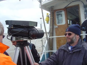
Tim LeBas (R) surveying his lightweight DIDSON mount!
